


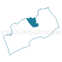
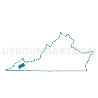
Cooks Mill Voting District, Russell County, Virginia
About
Outline

Summary
| Unique Area Identifier | 682500 |
| Name | Cooks Mill Voting District |
| County | Russell County |
| State | Virginia |
| Area (square miles) | 25.43 |
| Land Area (square miles) | 25.33 |
| Water Area (square miles) | 0.10 |
| % of Land Area | 99.60 |
| % of Water Area | 0.40 |
| Latitude of the Internal Point | 36.99455120 |
| Longtitude of the Internal Point | -82.08399200 |
Maps

Graphs
Select a template below for downloading or customizing gragh for Cooks Mill Voting District, Russell County, Virginia


Neighbors
Neighoring Voting District (by Name) Neighboring Voting District on the Map
- Cleveland Voting District, Russell County, VA
- Council Voting District, Buchanan County, VA
- Daughterty Voting District, Russell County, VA
- Honaker Voting District, Russell County, VA
- Hurricane Voting District, Buchanan County, VA
Top 10 Neighboring County Subdivision (by Population) Neighboring County Subdivision on the Map
- Lebanon district, Russell County, VA (14,477)
- New Garden district, Russell County, VA (7,347)
- Castlewood district, Russell County, VA (7,073)
- Hurricane district, Buchanan County, VA (3,415)
Top 10 Neighboring Unified School District (by Population) Neighboring Unified School District on the Map
Top 10 Neighboring State Legislative District Lower Chamber (by Population) Neighboring State Legislative District Lower Chamber on the Map
Top 10 Neighboring State Legislative District Upper Chamber (by Population) Neighboring State Legislative District Upper Chamber on the Map
Top 10 Neighboring 111th Congressional District (by Population) Neighboring 111th Congressional District on the Map
Top 10 Neighboring Census Tract (by Population) Neighboring Census Tract on the Map
- Census Tract 302, Russell County, VA (5,469)
- Census Tract 107, Buchanan County, VA (4,029)
- Census Tract 305, Russell County, VA (2,115)